
|
 |
|
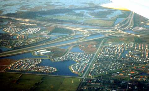
| High speed interchange, facing north, showing development and transportation along the northern edge of the C-11 West Basin, Broward County, Florida. The C-11 West Basin includes the lower 2/3 of this image, and is separated by the North New River Canal from the areas to the north. The interchange is the convergence of Interstate 75 (I-75) coming from the direction of Naples in the upper left (west), which curves around to the lower left (south), headed through Sunrise, Weston, Pembroke Pines, Hollywood, Miramar, and western Miami-Dade County. The Sawgrass Expressway, a toll road, comes from the direction of Coral Springs through Sunrise in the upper right (north). Interstate 595 (I-595) comes from the direction of Fort Lauderdale to the right (east). The street running from left to right in the foreground is SW 14th Street, and it forms a "T" with SW 148th Ave. To the right is the Shenandoah development in Davie, and to the left is Shotgun Road in Sunrise, curving through the Broward Lakes, and to the far left on the other side of I-75 are the areas of Woodgate, Hampton Lakes, and Westgate Square in Sunrise. The triangular watery area in the background, under the airplane wing, is Broward County's Markham Park. The area in the far background is Water Conservation Area 2B, separated from Markham Park by the L-35A canal hidden by the dark diagonal line of trees, mostly Casuarina, the Australian pines. | |
The C-11 Basin is a region of west central Broward County, Florida, the western portion of which is drained into the Everglades through the C-11 Canal. The C-11 West Basin is an area of 72 square miles (45,701 acres), which includes five municipalities (the Cities of Cooper City, Pembroke Pines, Sunrise, and Weston and the Towns of Davie and Southwest Ranches). The C-11 West Basin has experienced a population explosion since 1985.
The C-11 Basin is part of the original Everglades, and would naturally have standing water many months per year. The original inhabitants of the C-11 managed to live on the few tree islands, and navigated by dugout canoe. Conservation areas in the background of Interstate-595 show approximately what the area looked like before massive drainage projects, road construction, dredge-and-fill, and construction activities were initiated. Now the residents of the area are working together to reduce the impacts of their livelihood on the surrounding environment.
Numerous governments, agencies, and associations are directly responsible for the C-11 Basin. Just the management and permitting of water use is controlled and/or managed by the South Florida Water Management District and three Special Districts, the Central Broward Water Control District, the South Broward Drainage District, and the Indian Trace Development District governed by the City Commission of the City of Weston working with other municipalities and two Divisions of Broward County government, as well as homeowners' associations (HOAs) who are often responsible for some aspects of canal and lake maintenance. Other state and Federal agencies, such as the US Army Corps of Engineers (US-ACE) are responsible for broader issues of canal management and Everglades Restoration. Other environmental and human issues in the C-11 are handled by still more governments and agencies.